In November 2021, the Institute of Applied and Computational Mathematics, Foundation of Research and Technology-Hellas, in Heraklion, Greece launched a pilot web site for the visualization and searching of the historical maps of Candia (old name for Heraklion, Crete). The site includes information for several historical maps (from the 17th century and onwards) and permits users to make queries with respect the map characteristics and the geographic information depicted.
The Arches Project team discussed with Eleni Gkadolou (Post-doctoral Researcher) and Poulicos Prastacos (Director of Research, Principal Investigator of the Historical Maps of Candia project) the project’s aims and their experience implementing Arches software.
This interview has been edited for length and clarity.
~~~~~~~~~~~~~~~~~~~~~~~~~~~~~~~~~~~~~
Arches Project: Please introduce yourself and describe your role as part of the Historical Maps of Candia Project.
Eleni Gkadolou: I am a surveyor engineer, and my PhD was on historical maps and on implementing standards and ontologies to describe historical map collections. Part of this research was the development of an application profile for the documentation of historical map collections. It was based on the CIDOC-CRM model and thus we were searching for an open-source software that could support the visualization of the data produced based on this reference model. And this is how we decided to use Arches.
Poulicos Prastacos: I was the project manager of this project, but it was Eleni that did all the work. She was the one that decided to use Arches in this project. We were a little bit familiar with Arches since 2015. At that time we wrote a paper comparing different national/regional cultural heritage websites in Europe and how they are portrayed on maps. Arches had just been on the market, so to say, and of course we were very excited. It was Eleni’s decision to use Arches, and she was successful in assembling the data set and developing the software that permits users to retrieve information from the maps.
Eleni Gkadolou: As I said before, we decided to use Arches because we were looking for a software that supports the CIDOC-CRM, which is a very significant aspect for this project. Another important reason for selecting Arches was the GIS capabilities of the software since they permit the creation of spatial data from the maps and their visualization within the Arches framework.
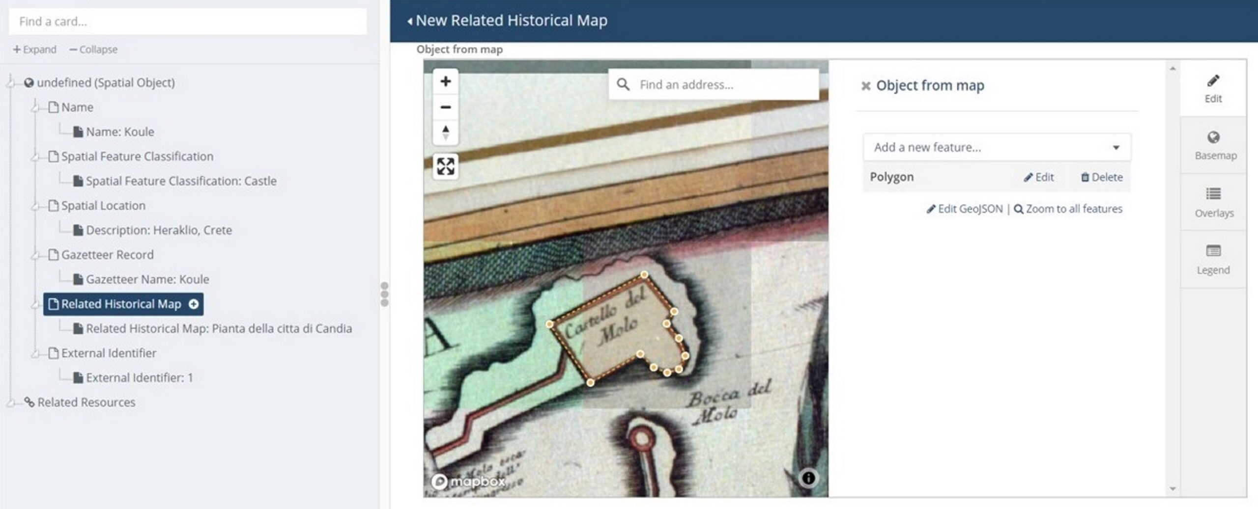
Creating a geographic entity from the map “Pianta della citta di Candia” in the Historical Maps of Candia implementation
Arches Project: From what I understand, this is the first time that Arches has been used to document and manage historical maps?
Eleni Gkadolou: Exactly. Historical maps are digital objects, digital resources, and cultural heritage resources and this case study could be well supported by Arches.
Poulicos Prastacos: Historical maps are not the typical cultural heritage objects because they portray the spatial/geographical dimension. Existing software for cataloging digital maps is often similar to that used for numerical type databases. This means that users can search the database, retrieve from different collections, but usually they cannot perform a spatial search and ask what kind of historical maps exist for an area or what are the toponyms displayed on a map from the 17th century? With the application we developed that uses Arches, you have this capability.
Arches Project: Why are historical maps such a valuable tool in historic and cultural heritage research, and how does Arches help you capture data about them?
Eleni Gkadolou: A historical map is a very peculiar cultural object; it is a cultural artefact that represents the history and the scientific map methodologies used in the past, but it is also a piece of art. And apart from that, because of the geographic coordinates, it is a mathematical object and can provide historical spatial data that cannot be found from anywhere else. And all these dimensions of a historical map are included in one object. Therefore: it is a cultural item, a piece of art, a mathematical object. And of course, it is a primary historical source.
Poulicos Prastacos: Historical maps specify geography, but also, they have annotations of different labels, which were written many years ago. For example, if you read a historical map of 200 years ago, you will see the names of different neighborhoods, or different landmarks, that do not exist nowadays, or are referred to with different names. In countries like Greece in which a lot of history has happened in the last 500 years, historical maps are important as a cultural object but also because they provide information on how that history has changed through time.
Of course, very often it’s not easy to analyze annotation that exists on a map. And that’s why Eleni and other researchers are researching how to extract this information from these maps and then through Arches, to directly input that into the coordinate system so it is registered.
Arches Project: Did you have any particular issues or concerns when you were geographically registering these maps?
Eleni Gkadolou: Not really. We had maps that were georeferenced anyway, therefore, we added them up as map layers. We set up a map server with open-source software to implement this. Another thing that was quite useful to us was the ability we had in Arches to visualize the georeferenced historical maps as overlays on current base maps.
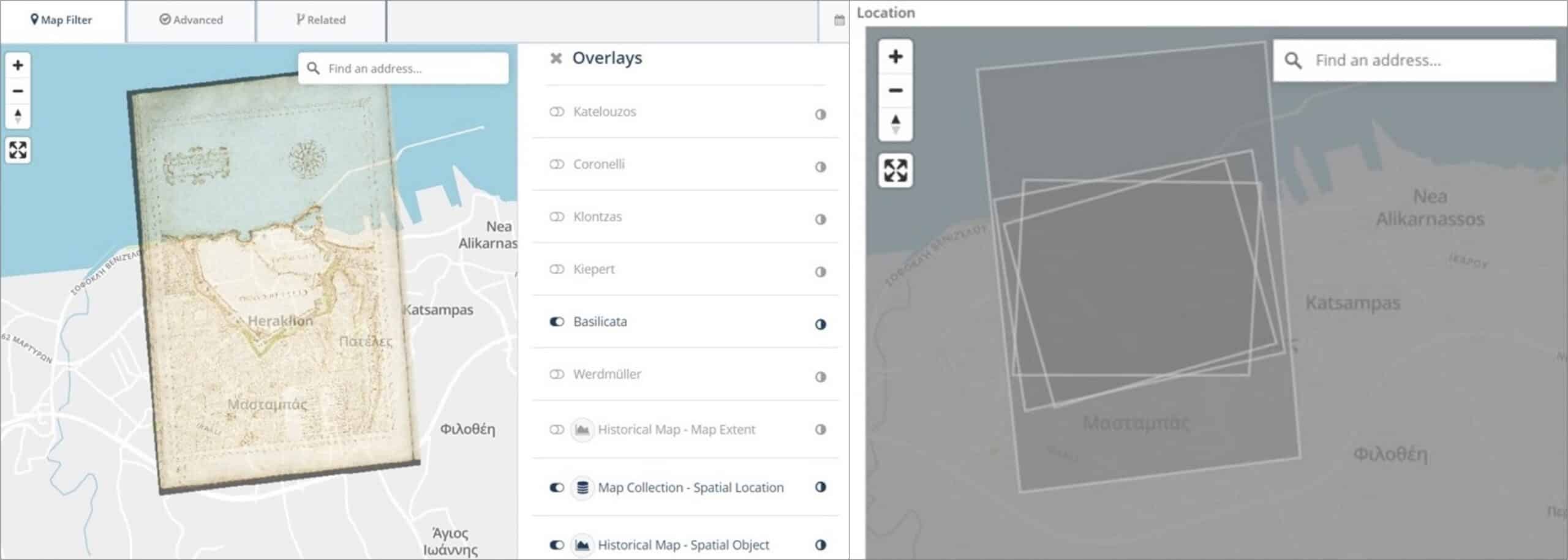
Representation of historical map overlays in the Historical Maps of Candia implementation, including the georeferenced map «Citta di Candia» of Basilicata visualized on top of modern map (left) and the cartographic extents of the six maps of the case study (right).
Arches Project: Were there any rights issues with these maps and did you handle that in any particular way?
Eleni Gkadolou: The Historical Museum of Crete provided the scanned images of the maps for this research project.
Poulicos Prastacos: They are public maps that are available either in museums or in private collections. And we obtained digital images, which are openly available.
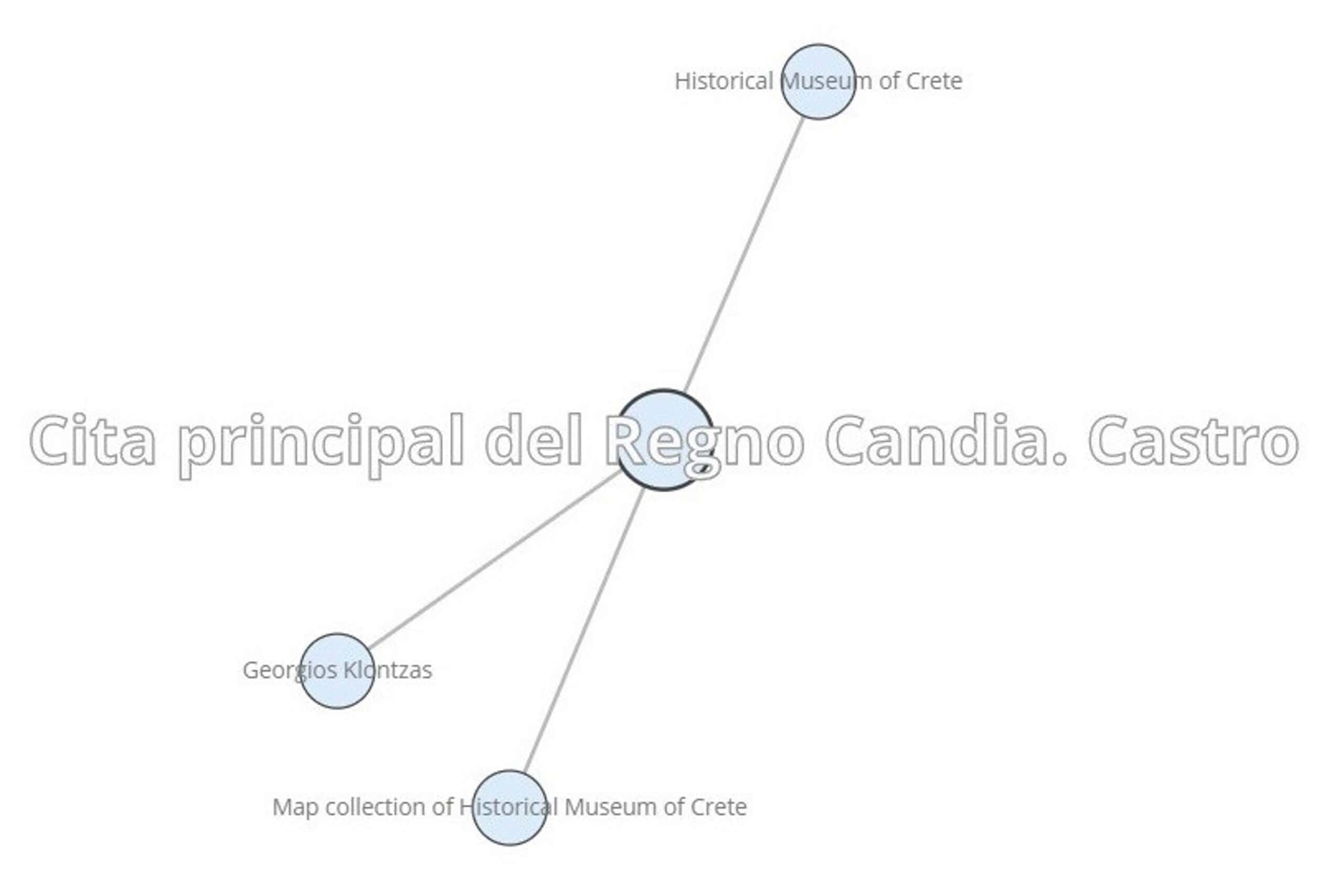
Visualization showing the resource relationships of map «Cita Principal del regno Candia», including its connection to the map collection of the Historical Museum of Crete.
Arches Project: To whom is this implementation accessible? Who can look at the data and the maps that you’ve put into Arches?
Eleni Gkadolou: We did not specify different levels or restricted the access to allow access only to specific users. This was not a concern in this project. For the time being it is open, we are trying to present it to people that might be interested in collaborating with us and extend the idea and obtain funding for a larger project.
Actually, what we would like to do is to develop an integrated solution to present to online museums, not only for historical maps, but also for other cultural heritage collections that are complementary. For example: archival material or museum objects by archaeologists that came to Greece, made the excavations, had their own maps and created annotations on top of the maps. We have not customized the web interface towards this direction but perhaps, but we will do it in a future project.
Poulicos Prastacos: We would use Arches not only for the maps, but also showing different things like diaries of travelers, which is nowadays a very interesting area of research in the cultural heritage field. There is a lot of discussion about European historians that visited Greece in the 17th and 18th centuries before and after Greece was liberated, where they went and how they described in their diaries the topography, the social conditions at that time, etc. And we think that all of these could be somehow shown with Arches.
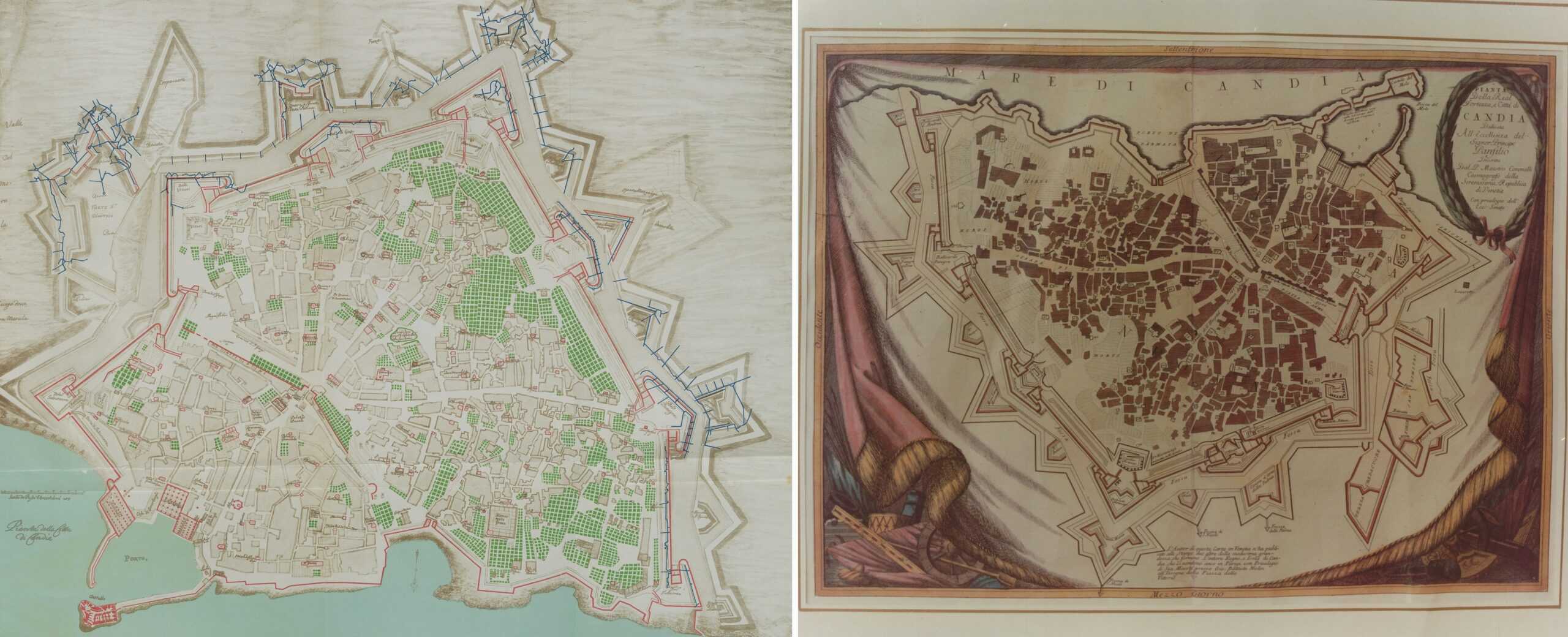
The map “Pianta della citta di Candia” of Werdmüller (left) and the map “Pianta Della real Fortezza, e Citta di Candia” of Coronelli (right). Both digital maps are provided by the Historical Museum of Crete.
Of course, some of these can be shown with classical GIS software like ArcGIS, QGIS etc. And there might be relevant projects that develop sites using a typical GIS software, which I think is reinventing the wheel. Spending a lot of time and resources for issues that have been already solved… People often want to develop everything from scratch because they have funding, therefore, developers will create everything from scratch.
Arches Project: Are there any other Arches features that are particularly useful for your implementation we have not yet discussed?
Eleni Gkadolou: To sum it up, the most useful features of Arches are: the GIS capabilities; that you can load your own ontology, and that the software also supports CIDOC-CRM, a quite complicated reference model; the overlaying of spatial layers; and also the time wheel is another feature that can be very useful. We didn’t use it in this project, but there are ontologies for formalizing the time dimension (such as PeriodO for historical periods) that we could add in the future. And perhaps link them to the time wheel like this. This will give an added value to the project, since we’re concerned with cultural heritage data that directly refer to specific historical periods
Arches Project: What suggestions do you have for someone who is implementing Arches for the first me?
Eleni Gkadolou: Even though I’m not an IT expert, it wasn’t that difficult to implement Arches. During the development I had some technical difficulties; sometimes I couldn’t understand the reason behind it, but the community, the forum, where I posted my questions usually replied almost immediately. I had discussions with members of your team, and they provided solutions quite quickly. So I would say that the implementation was straightforward, the tutorials are really good and extended. Perhaps you could add some videos on the set-up and the IT difficulties users might encounter.
Poulicos Prastacos: My one suggestion is that it would be very helpful if sample data sets and the code for small [Arches] applications were available online. Then users could download them, and can do the steps for installation. This would be helpful to Arches users that want to do their own installation and develop applications with their own data sets.
Arches Project: Do you mean that it would be helpful to have a sample step-by-step process for particular implementations?
Poulicos Prastacos: Something like that. Also, I think it would be very interesting if you provide a catalogue of the type of [Arches] applications people have developed. This will be very helpful to users because they could see what has been implemented in different places and this will give them ideas for developing applications with their own datasets.
Arches Project: I’m glad to hear that the forum was useful when you were getting set up. Were there any other Arches resources that you used?
Eleni Gkadolou: Everything that was on the site, it was used. As I said, I’m not an IT expert and I guess this is the case for most smaller organizations that want to develop Arches based applications and do not have significant funding. The very good and helpful technical community that Arches has provides support to people with limited IT expertise. I think this gives added value to the software.
Arches Project: Is there anything else you’d like the Arches community to know about your project?
Eleni Gkadolou: That we’re trying to extend it: following the approach we already mentioned, we would like to extend it by adding a crowd-sourcing perspective, to invite people to use it and create their own data. Provided we obtain funding, yes, we want to further enhance the application and develop an application with a larger dataset.
Arches Project: Thank you for sharing your experience and finding time to talk to us. We thought it was very interesting that you did choose Arches for your project, even though there were no implementations previously that were looking at looking at maps as objects. So thank you!
Poulicos Prastacos: Thank you for developing the software!
Do you have an Arches implementation and want to share your story with the wider community? The Arches team is looking for others to interview about their experience. Reach out to us at contact@archesproject.org.